5K Course Description
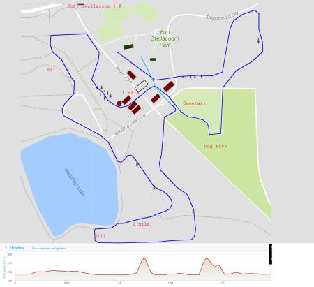
View the Fort Steilacoom 5K map here.https://fort-steila-coom-invite.com/wp-content/uploads/2019/01/ftsteil-map-2017.jpg?w=450
The course is 5000 meters entirely within Ft. Steilacoom Park in Lakewood. Both the start and finish are in the grassy area by the “historic” barns and play area. The first mile is generally flat and open. Runners head out from the start line which is deep in the meadow and to the south of the large picnic shelter. As they approach the end of the maintenance area (there is a concrete pad on the right), they will make a sweeping left turn. They head out towards the field with the radio aircraft area on their right. They will run a loop in the fields heading towards the road and main entrance. After leaving the path parallel to the park road, the course heads back towards the left of lone fir tree and then to the cemetary.The course follows the dirt road between the cemetary and dog park, and then crosses the road and goes between the two barns. It then makes a left turn and runs along the maintenance area hedge row towards the old silo and more barns. The mile is by the left turn to run alongside the hedge row. There is a hill at about 1 ¼ miles leading up to the Hill Ward site. From there, the runners head down to the lake (runners need to stay on the gravel to the right of the paved pathway). Once they reach the lake they can run on the path or on the grass/dirt on the left of the lake trail. They will trun left and go into the fields by the shelter on the lake trail. They will run through the fields as they approach the two mile mark. As the runners approach the lake again, they should stay on the grassy area to the left of the lake path. They will take the first left turn on the lake path going up another steeper hill of approximately 175 meters. At the crest of the hill, the runners turn left down a gently descending path through the woods, coming out at another set of fields. At this point, runners are just over 1000 meters from the finish. Runners cross through the fields to a tree covered avenue. About 600 meters from the finish, the course turns to the right and head back towards the dog park. The dog park is approximately 400 meters from the finish.
The majority of the course is grass and dirt trails, with a little bit of gravel road thrown in for variety. There is a small amount of pavement (less than 5%). This is a good viewing course. The runners are in full view for most of the first mile, the middle, and again most of the last mile. With just a little bit of walking, coaches can see their runners for about 70% of the course. The course is wide open, with plenty of room to race, and with terrain for both “strength” & “speed” runners. Those runners who lose their focus can enjoy the fall foliage, the scenic & historic barns, and a lovely view of Mt. Rainier over Lake Waughop. Spikes are recommended.
